Non-profit AI data tool helping cities predict urban heating effects
Why It Matters
Applying predictive models and machine learning to a dataset can help municipal governments understand where to direct funding for urban cooling infrastructure. However, developing and maintaining the appropriate digital tools can be challenging.
An evolving tool that uses predictive models and AI learning could be an instrumental resource as Canadian cities grapple with heat islands due to climate change.
In 2022, the Regional Municipality of Peel joined Evergreen’s ongoing work on AI for the Resilient City.
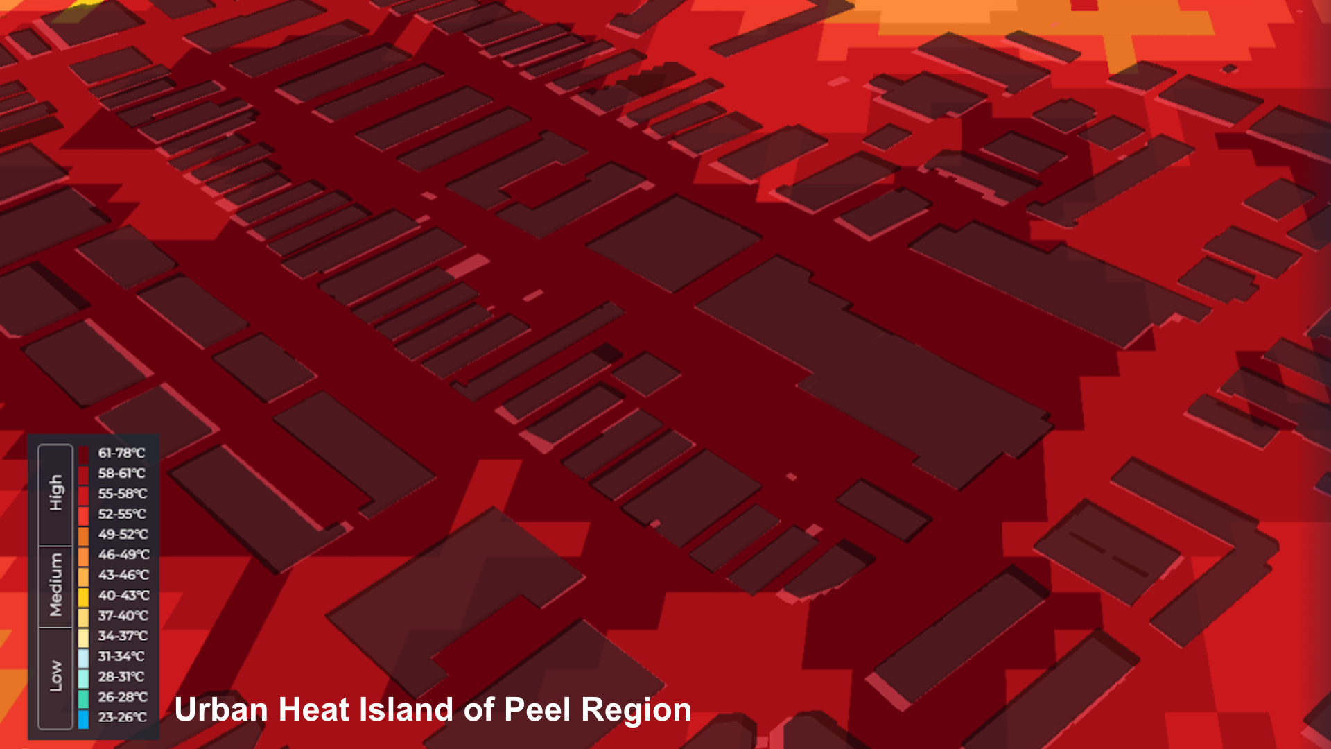
This tool uses open data sources to map the Urban Heat Island effect (UHI) in particular regions.
Over the past decade, a series of drastic weather events have hit the Peel region, say Jeremy Schembri, manager at the Region of Peel’s Office of Climate Change and Energy Management, and Craig Moffitt, manager at the Peel Data Centre in the regional government.
The cities of Mississauga, Brampton and Caledon, which make up the Peel region and sit just west of Toronto, have seen widespread flooding from record-breaking rainfall in 2013, an ice storm in 2013 that caused massive damage, a windstorm in May 2018, and more record precipitation and wind in May of 2022.
The cost of these events was in the hundreds of millions of dollars in the Greater Toronto Area, including the Peel region, said Schembri and Moffitt.
Evergreen, whose work focuses on developing and preserving green public spaces, began developing the tool in 2020 in partnership with Gramener, a data analytics, engineering and AI company.
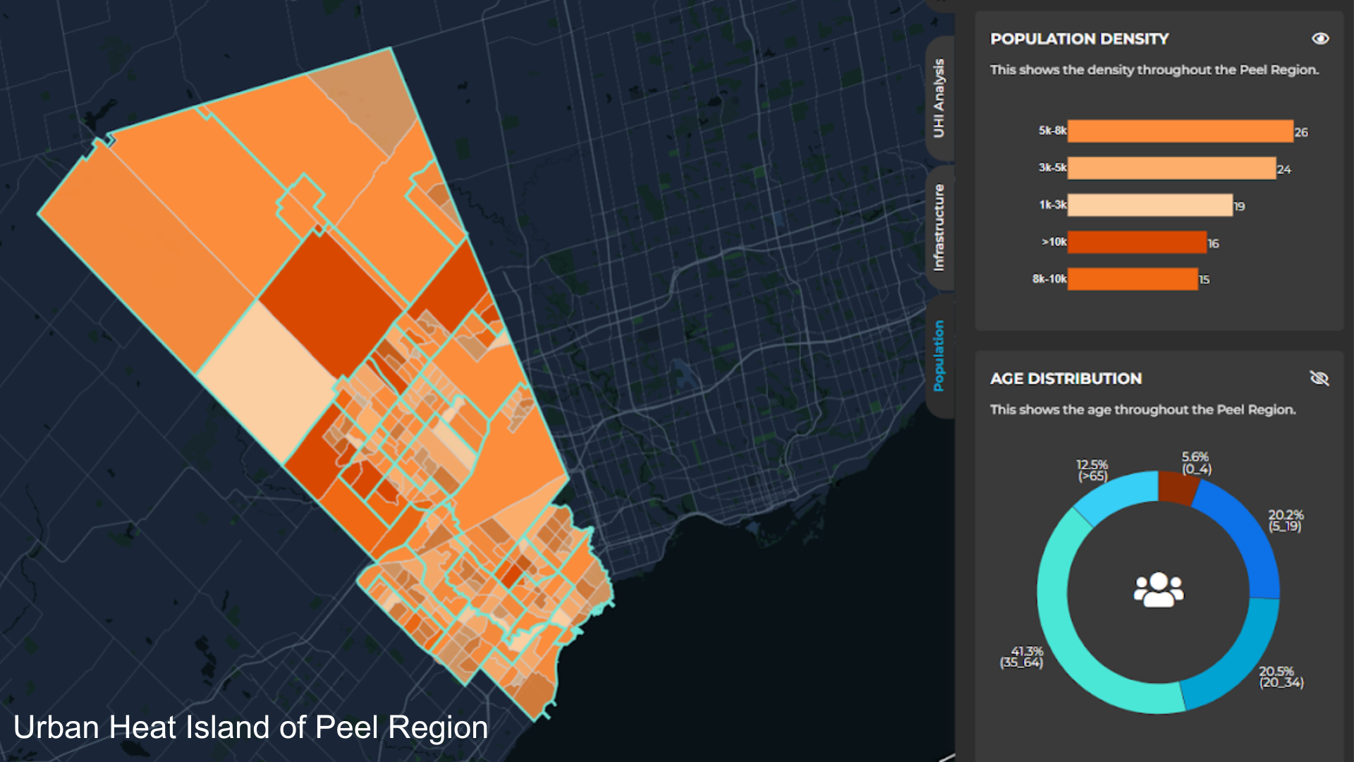
AI for the Resilient City uses geospatial satellite imagery, local heat data, infrastructure data and demographic data from 2013 to 2022 to produce visual representations of the UHI in particular areas, said Joshua Welch, program officer at Evergreen.
Once the data is cleaned, processed and analyzed, the final result is a dashboard showing municipal governments the areas most affected by temperature increases.
The non-profit received seed funding from Microsoft to develop the tool and is now supported by the Royal Bank of Canada (RBC).
In early 2023, Evergreen launched the Scenario Mode of AI for the Resilient City. This new function relies on predictive analytics and scenario modelling – it allows municipal governments to assess how proposed urban infrastructure, including new buildings and natural assets like parks and water bodies, might have a heating or a cooling effect.
“It gives users the ability to understand the heat and UHI impacts of infrastructure changes on the environment before any plans are ever approved and shovels ever hit the dirt,” said Welch.
To date, this functionality is only available to the Regional Municipality of Peel teams.
“When we first spoke to our partners at Region of Peel about introducing this function, they thought it would help them to better evaluate planning and development projects, as well as extreme heat strategies related to urban tree cover,” Welch said.
“Over the course of planning together, they developed further ideas like infrastructure assessments, climate change strategy updates, green development standard considerations and more.”
How have municipal governments used Evergreen’s tool?
Aside from the RM of Peel, Evergreen has also worked closely with the City of Calgary on UHI mapping. In both cases, the municipal governments can provide additional supplementary data to ensure that the data is as relevant to the location as possible.
“One area that we’re interested in pursuing would be incorporating high-quality tree canopy cover or vegetation data,” Welch said.
However, he added, most of the data the tool relies on is still open-source information.
“Many municipalities only complete studies over a specific number of years, and while this point in time can be valuable, it would have a dramatically larger impact on the program if that was, for example, annual data, or recurring in a [more] timely fashion,” he said.
The Region of Peel included information about building outlines and heights alongside canopy cover data to ensure that the data visualizations created by the tool were more relevant to the region’s needs. “This will be particularly important as Peel transitions from lower density built forms to higher density neighbourhoods,” Schembri and Moffitt said.
Meanwhile, in Calgary, the city government used Evergreen’s tool to support five planning projects and ten public infrastructure projects, as well as to find quantitative data that showed how parks and bodies of water had cooling effects in certain parts of the city.
The visualizations that the tool produced also allowed the city government to develop targeted communications and support services to those most vulnerable to urban heating and inform neighbourhood-level planning for cooling infrastructure, said Florentin Wecxsteen, a climate adaptation specialist at the City of Calgary.
After using Evergreen’s app for some time, the City of Calgary decided to develop its own in-house Urban Heat Mapping tool.
Along with data on land surface temperature, vegetation and urban infrastructure, the City also included data about vulnerable age groups and populations, Wecxsteen added.
How can a non-profit sustain a technology or data product?
The City of Calgary may have created an in-house data platform to map urban temperatures, but Evergreen plans to onboard two new municipalities onto the AI for the Resilient City tool soon.
The team is also looking into a public-facing version of the tool.
“We also want to explore adding a social vulnerability layer for census tract-level detail to better understand the correlation of risks that are associated with the most vulnerable populations when talking about UHI and extreme heat,” Welch said.
However, the more complex the tool’s functionality becomes, the more difficult it is to maintain technically and financially.
Welch said that there are three main buckets of costs to consider: technical back-end and front-end of the application; maintenance costs and upgrade costs, which increase when datasets are updated; and ongoing IT storage costs, which “may significantly shift or increase once the machine learning algorithm comes into play, and may vary from month to month depending on the usage.”
With its corporate funding through RBC’s Tech for Nature program, Evergreen is currently assessing the long-term sustainability of a non-profit data tool.
The non-profit hopes that this funding will build commercial longevity for the tool and ensure that Evergreen can do so while remaining a non-profit organization, Welch said.
Tell us this made you smarter | Contact us | Report error