Can geospatial data help communities prepare for natural disasters? Here are the lessons from Türkiye and Syria.
How open data and mapping can help disaster response organizations go from reactivity to preparedness.
Why It Matters
Location-based, openly available data – which is crowdsourced across a community, or from around the world – can help those working in aid contexts ascertain where the need for resources is most urgent following a disaster. However, constant and preemptive data collection activities – both before and after a disaster – could help aid workers and government agencies proactively plan for such disasters.
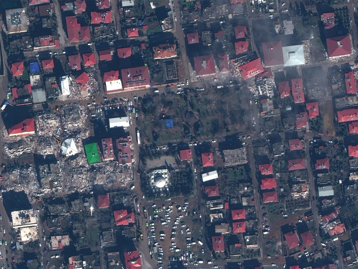
Image Caption: Satellite images captured by Maxar Technologies, showing collapsed buildings and rescue operations taking place the day after the earthquake, in the Turkish city of Ishahiya. [Satellite image ©2023 Maxar Technologies]
Dr Bilgehan Çevik, an orthopedic surgeon based in Ankara, Türkiye, wanted to volunteer in Antakya, one of the regions most devastated by the earthquake in February. With local communications infrastructure destroyed, Çevik and a team of other volunteer doctors found it challenging to navigate the roads of the region using internet-based map services. Instead, they ended up relying on offline maps to get to their destination.
Similarly, Dr Mehmet Faruk Uçum, a physician in one of the newly-established tent cities, used OpenStreetMap (OSM) to map the layout of the shelter, and prevent breakouts of contagious diseases by managing public health in the environment.
OpenStreetMap is a database that relies on volunteers around the world to collect, amend and input location-based information. Launched in UK in 2004, volunteer mappers gather and input data from “aerial imagery, GPS devices, and field maps”, collectively building accurate maps at hyperlocal levels. Crucially, the data is free to use.
OSM is fast becoming a critical tool in informing emergency response, both in Türkiye and Syria, and beyond. One month after the quake happened, the Humanitarian OpenStreetMap Team (HOT) reported that it had mapped not only roads, but critical infrastructure, like hospitals, food depots and new settlements, as well as any damage to buildings. Aid agencies, such as Türkiye’s Ministry of Interior Disaster and Emergency Management Presidency, and the Search and Rescue Association, reported using the maps to logistically coordinate where to send emergency resources.
For Nama Budhathoki, a member of HOT’s leadership team and the regional director for Open Mapping Hub Asia-Pacific, this is a tool that has become more prominent in the volunteer humanitarian aid space. Since anybody can download and access both the tools and the maps, nearly 9,000 volunteers globally have participated in mapping the affected areas in Türkiye and Syria, he says. The UN Mappers ran a similar initiative, too, convening more than 400 volunteers from around the world to map 17,000 buildings in the immediate aftermath of the earthquake.
While a lot of the people who belong to the OSM community are “enthusiast mappers [or] GIS professionals”, there is also room for inexperienced volunteer mappers to train up: for instance, HOT offers courses in data reporting, validation and community care, which is vital when collecting information about vulnerable communities who have recently been affected by a disaster. In addition, through the UN Maps Learning Hub, UN Mappers offers OSM training at both basic and advanced levels, widening the pool of mappers who can partake in data collection and validation during times of crisis.
OSM can also be used offline, making it a tool that works well in the context of disaster regions, Budhathoki adds. “You don’t need to be continuously connected to the internet. You can work for a few hours and then upload when you get to an internet cafe. In some countries, people do a lot of mapping [themselves] and then take it to the regional coordinator to upload.”
However, sophisticated geospatial mapping relies on availability of location-based data in the first place, which is why both governments and aid agencies need to be able to actively collaborate with mappers. “When there is a disaster, the geography [of the area] changes in a few seconds,” Budhathoki adds. In that environment, the data needs to be as up-to-date as possible to be useful to aid agencies and emergency responders.
What sorts of data are being collected and communicated to emergency responders on the ground?
“The kind of information we produce depends on a number of things,” Budhathoki says. “The first is the nature of the disaster: is it an earthquake, or a flood, for example? There isn’t one set of information that satisfies the needs of first responders in all situations.” For instance, the International Federation of the Red Cross requested building-level information about the scale of damage, which was gathered for them by Yer Çizenler, a local NGO in Türkiye specializing in geospatial analysis for humanitarian contexts. That then helped them to plan their relief and recovery logistics at a hyper-local level.
“In the first one or two days [after a disaster], you don’t get a lot of communication, because communication lines themselves are down,” says Can Ünen, co-founder of Yer Çizenler in Türkiye and a member of staff at HOT. In that chaotic situation, he adds, those trying to rescue people or distribute resources will need to rely on data that already existed prior to the disaster.
After that, any information or data changes rapidly, and so it requires coordination from both mappers working remotely and emergency responders on the ground, so that the data can be kept up-to-date. “After an earthquake, in very cold temperatures, it is useful to know at a glance how many shelter organizations are working in each district, to ensure that no community is being left behind,” says Alex Macbeth, head of communications at MapAction, a UK-based charity using geospatial data and maps in disaster situations, who have been producing maps for Türkiye and Syria.
“New aid organizations are arriving and others leaving, daily. As a result, a new 3W Map [which covers who is providing what kind of support and where] pinned to the wall of a district coordination office on Monday is covered in pen and Post-It notes by Wednesday, and has changed again by Friday. 3W must be remade, sometimes several times a week.”
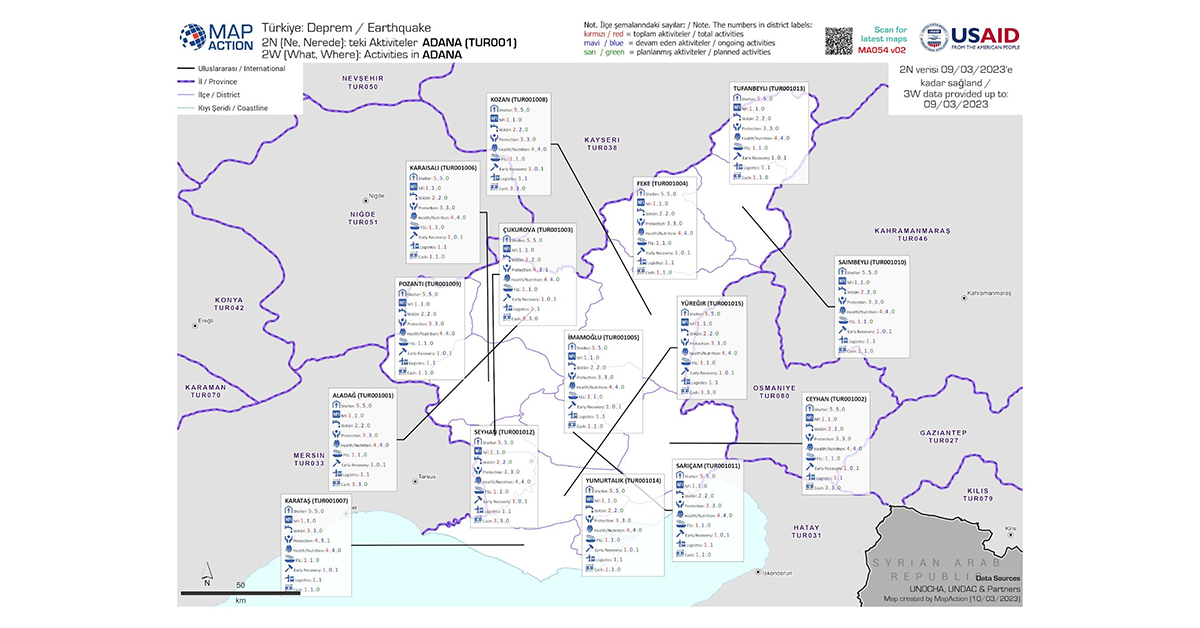
Image Caption: Produced by MapAction, this digital map shows a breakdown of aid activities that are ongoing and planned in each region of Türkiye affected by the earthquake, such as shelter facilities and health and nutrition services. [Image courtesy of MapAction].
At the moment, although “the need for very rapid map turnaround has passed”, MapAction is updating the maps on a weekly basis, Macbeth says. “The data will come from a range of sources – sometimes it will be the national disaster agency, and other times the relevant UN or regional partner. In this case, UN OCHA (United Nations Office for the Coordination of Humanitarian Affairs) provides the data, and we will carry out checks and format the data. The maps are produced at the request of UN OCHA and UNDAC (United Nations Disaster Assessment and Coordination), who share them through their networks with other local partners on the ground.”
The availability and usability of existing datasets drives how effectively a location can be mapped, which is why mappers require extensive collaboration with local communities, aid agencies on the ground, and local / national governments. For instance, in Türkiye, MapAction has been able to build extensive datasets of who is working to distribute a number of different resources within each region in the affected provinces, including temporary camp locations, food security organizations, and debris removal services. It has also been able to map each region by its population and the intensity of the shake it felt during the earthquake. In comparison, data from the countries impacted by Cyclone Freddy in March 2023, such as Malawi, Mozambique and Madagascar, is relatively sparse.
“There is a variety of open data available in many countries, but map and location data is still a huge challenge in the developing world,” Budhathoki adds. On top of that, it isn’t easy to track exactly how maps are being used on the ground by aid agencies, Macbeth says.
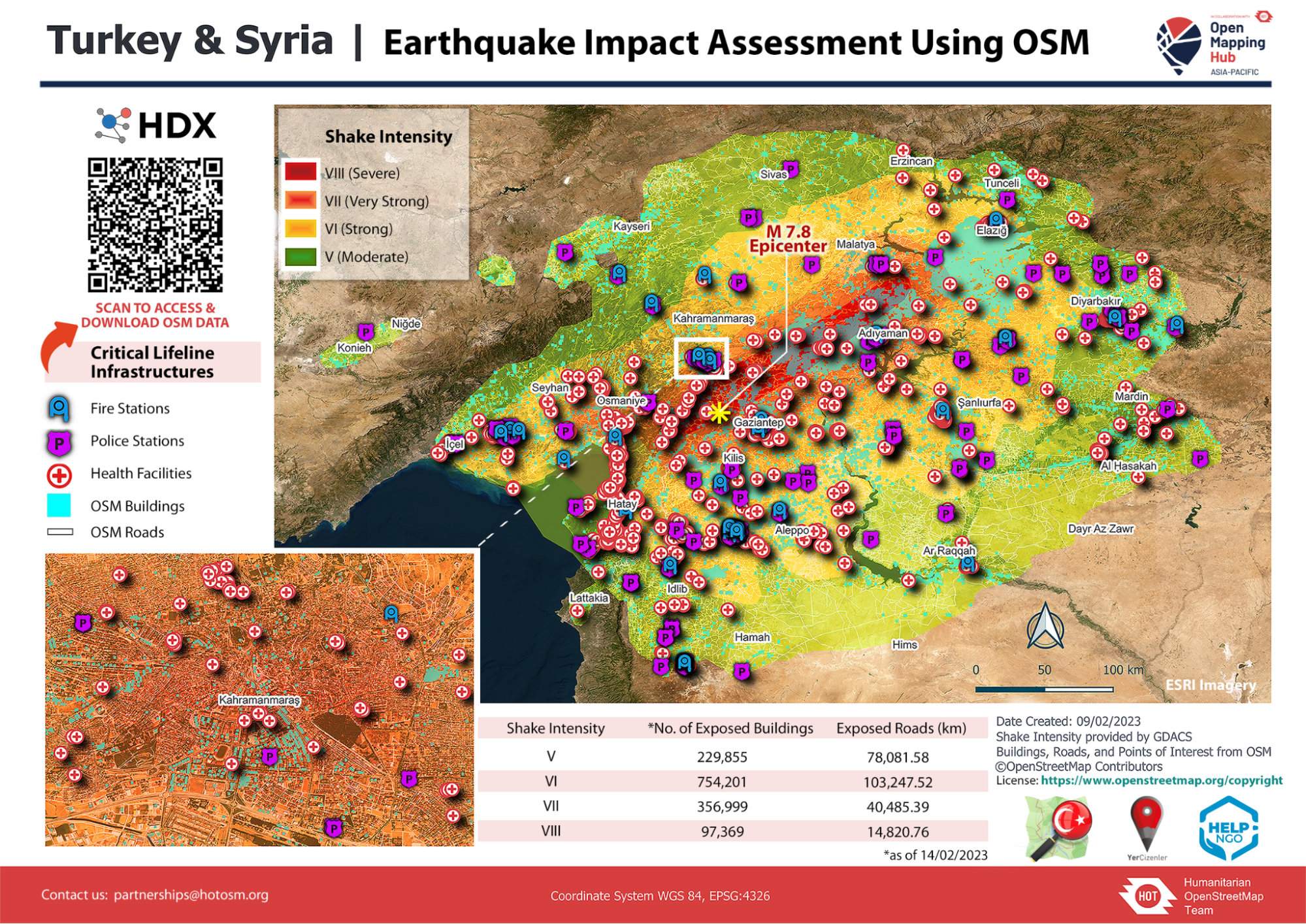
Image Caption: The above map, created by the Humanitarian OpenStreetMap team, shows the intensity of the earthquake in different parts of Türkiye and Syria, as well as making health facilities, fire stations and police stations. [Image courtesy of HOT]
HOT, for instance, provides some simple things to watch out for when validating a map, such as buildings and highways that overlap, features that are untagged, and consistent major road names. Only intermediate and advanced mappers work on maps of high-density urban areas.
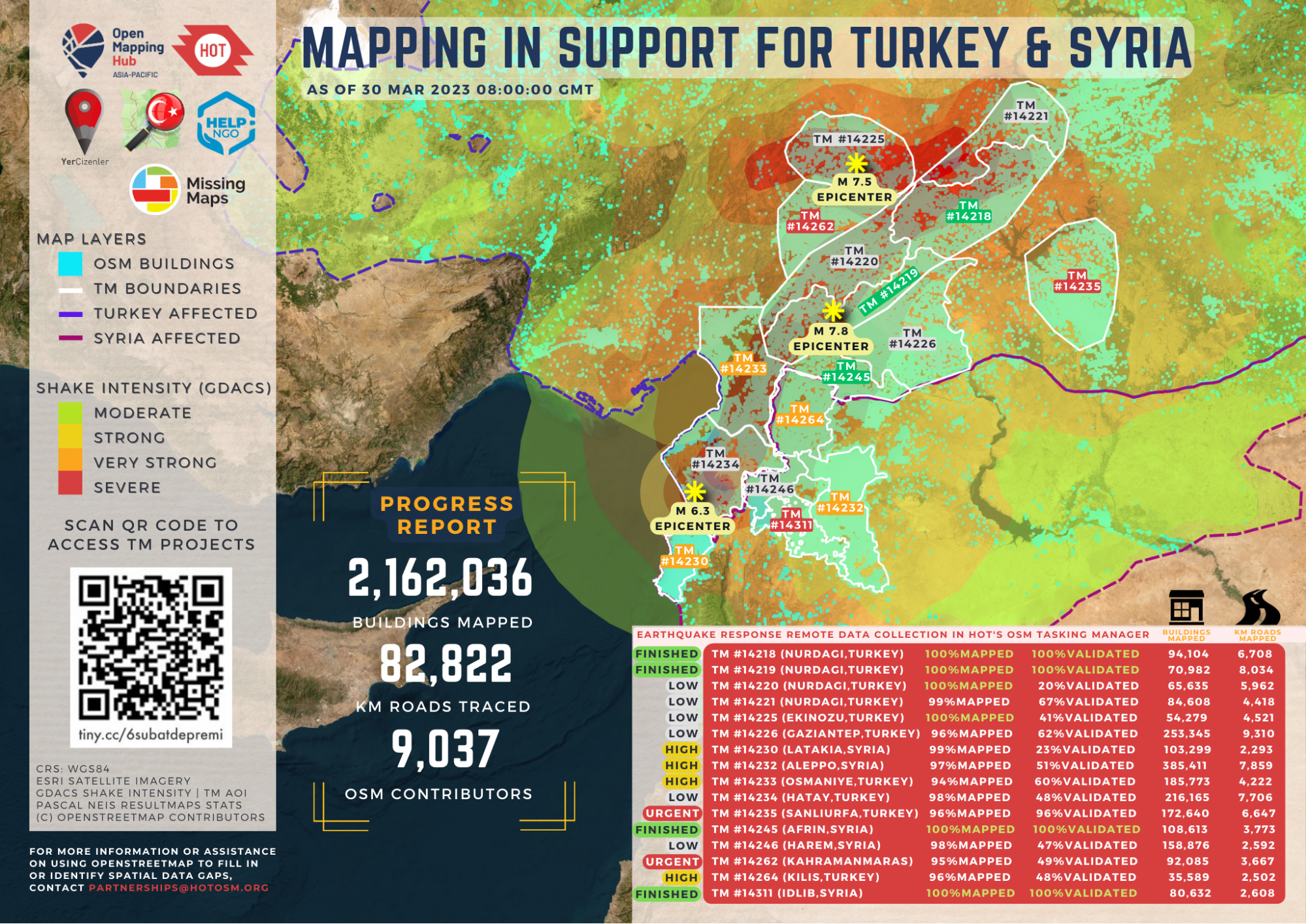
Image Caption: A snapshot of the progress made on mapping the affected regions by volunteers mapping for the Humanitarian OpenStreetMap team. [Image courtesy of HOT]
For example, when Türkiye was hit with an earthquake in 1999, “there was lots of water and bread transferred somewhere where people were not in need, so the bread went bad.” That shows, Ünen emphasizes, that there has to be an element of risk assessment and preparedness happening prior to an earthquake as well as after.
“Some of the data is correct, some is incorrect, and some is repeated. Multiple agencies and groups are repeating the same thing over and over again, which is wasting lots of precious time. Everyone has good intentions and a will to collaborate, but there is a lack of coordination – which is hard to prevent altogether.”
How can communities and local governments move from a place of reactivity to proactivity when collecting geospatial data?
But this is where citizens on the ground come in – there is only so much that mappers working remotely can discover. “Citizen volunteers who are already in the community can produce this data and map pieces of roads, schools and hospitals,” Budhathoki says. As governments begin to understand the value of this data, they could also save money by relying on volunteers to collect and map location-specific data, rather than sending government staff out to conduct mapping exercises, he adds. “The government and citizens can then work together to build a digital public good.”
Ünen says that in Türkiye, the mapping initiative has been entirely driven by a civil movement rather than government actors or organizations – many of whom haven’t even officially acknowledged the hard work that has been done by citizens on the ground.
“If everyone maps in front of their own doors, we’d have a complete community map,” Ünen says.
While citizen-generated data is relatively easy to collect on smartphones and personal devices, on the other end of the spectrum is satellite imagery, which can provide much more real-time and granular location information. Maxar, for example, is a Colorado-based technology company using satellite imagery to map both space and the planet. In times of emergency, “Maxar’s Open Data Program (ODP) provides imagery and related data to aid humanitarian crises,” says Desiree Petrie, head of Maxar’s Open Data Initiatives and senior manager of strategic growth at Maxar. “Maxar’s ODP Committee determines when to make imagery open to the public and partners based on our Disaster Response Activation Protocol. If the committee decides to open access to information, it releases the associated imagery into the public domain under a Creative Commons 4.0 license, providing easy and free access to organizations around the world. Since its inauguration in 2017, the ODP has released more than 2.6 million square kilometers of imagery.”
In Türkiye and Syria, Maxar has already provided more than 12,000 square kilometers of high-resolution satellite imagery from both before and after the quake, Petrie adds. For example, by combining satellite imagery with deep learning models, Maxar was able to detect where critical communications infrastructure had been damaged in the affected region. “As a result, [telecommunications] companies were able to deploy their resources more efficiently to restore phone and internet service in the areas that needed it most,” Petrie says.
While Maxar has been able to provide this real-time, location-based data to organizations like HOT, Esri Disaster Response Program, and Team Rubicon, there is one key challenge: “you can’t take optical images when it’s cloudy, which was the case in the immediate aftermath of the first earthquake,” Petrie reminds us. Ünen adds that while artificial intelligence has gone some way to helping gather location information, it can’t replace the strength of people gathering data on the ground. “There are some things from the field that AI cannot tell you – you still need humans to gather that micro-information. You can spend lots of money on complex solutions, but at the end of the day, pen and paper might solve the problem.”
It’s important to remember that mapping during times of disaster response isn’t a new activity in and of itself: HOT began in the aftermath of a major earthquake that hit Haiti back in 2010, and Budhathoki himself, before he joined the organization, led Kathmandu Living Labs, where the team led ‘crisis mapping’ activities in light of the 2015 earthquake. Similarly, UN Maps is an ongoing mapping initiative “that aims to assist UN Peacekeeping missions in their field endeavours, such as peace and security, navigation and logistics, by providing its peacekeepers with topographic maps that will help them in their tactical and operational activities.”
“We don’t wait for a disaster to start mapping – we have to improve the quality and depth of the data even in normal times,” Budhathoki emphasizes.
If people have already mapped cities, roads, hospitals and other critical facilities, that data already exists in times of crisis. “The question at HOT is how we can remain prepared before a disaster, which we call anticipatory action. It means that when we’re hit by an earthquake or any other disaster, we are ready within minutes. We can save more lives and help more people, because data and information is power.”
That preparedness, however, requires a number of different stakeholders to be brought in to build a collective database, from citizens and local agencies, to private technology companies and national governments. “The use of data has a cultural, technological and political context,” Budhathoki says. “In some societies, people are more reluctant to use data, because they don’t have enough data literacy, trust in data, or technological infrastructure.”
Your job. Your mission. Your news.
With your support, the sector you're building gets the journalism it deserves, and you get a tax receipt.
Author

Related Articles

CCNDR to expand cybersecurity resources for non-profits with new CoLab
In a recent survey of 8,000 non-profits, CCNDR also found that equity-denied organizations face significant barriers in digital skills and training.

Texting with a stranger beats a chatbot at easing loneliness: Canadian study
UBC-led study challenges the idea that an always-available AI companion can substitute for a human connection.
New AI tool aims to make Canadian federal politics easier to track
“CanadaGPT” is designed to simplify complex government activity by giving users a clear understanding of what’s happening in Ottawa.